Nepal’s Floods Began With a Glacier Collapse — Not an Earthquake | Explained
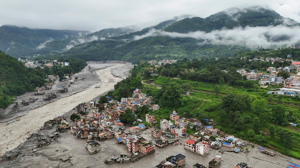
The catastrophic floods that swept through Nepal’s Himalayan border region on August 26 appear to have started with a massive glacier collapse, followed by an ice-and-rock avalanche that sent a surge of water and debris down the river system.
The latest evidence from the U.S. Geological Survey (USGS), satellite imagery, and scientists studying the event points away from an earthquake as the primary trigger. Instead, the seismic signal detected around the time of the disaster appears to have been generated by the collapsing glacier and debris flow itself.
That distinction matters because early reports had suggested that an earthquake in Tibet might have shaken loose the glacier and caused the flood.
What happened on August 26?
The disaster began at about 8:40 a.m. local time on Wednesday in the mountainous region around the Nepal-China border.
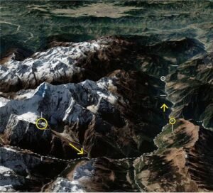
A large section of a glacier and surrounding rock collapsed at high altitude. According to the USGS, the source was a glaciated mountain cliff on the northern side of Langtang Lirung, a roughly 7,200-metre Himalayan peak. The collapse generated seismic energy equivalent to a magnitude 5.2 earthquake.
Satellite imagery reviewed by Reuters showed a substantial section of the glacier’s lower end had disappeared, leaving a heavily scarred mountainside covered in debris and sediment.
Scientists believe the falling mass consisted of ice, rock and other material. As it moved rapidly downhill, it entered the river system and picked up additional water, sediment and boulders.
The resulting debris flow travelled roughly 100 kilometres through the mountain valleys, according to the USGS.
So was there an earthquake?
This is where the story became confusing.
Nepali officials initially suspected that an earthquake may have triggered the glacier collapse. The Kathmandu Post reported that Nepal’s foreign minister told Parliament that an earthquake had been detected at about 8:37 a.m., only minutes before the flash flood was reported.
At the time, officials were still trying to establish what had happened because communications with the affected border region were severely disrupted.
India’s National Remote Sensing Centre also carried out a preliminary satellite assessment. A report published by NDTV on August 27 said NRSC scientists considered the possibility that a magnitude 4.9 earthquake had triggered the collapse of a cirque glacier.
But subsequent analysis by the USGS produced a different explanation.
The agency said its analysis of seismic waves located the source in a glaciated mountain cliff. The collapse itself generated energy equivalent to a magnitude 5.2 earthquake.
In other words, the ground shook because the mountain and glacier collapsed — rather than the ground shaking first and causing the collapse.
Reuters also reported that the USGS determined the seismic energy was generated by the collapse of glacial rock and ice, followed by the debris flow.
The distinction is important: there was a seismic signal, but the strongest available evidence does not support describing an earthquake as the established cause of the flood.
How did a glacier collapse become a huge flood?
The disaster appears to have unfolded as a chain of events.
First, part of the glacier and adjacent mountain material broke away at high altitude.
The falling ice and rock then crashed into the valley below, generating a powerful debris avalanche. Some of that material entered the Lhende Khola river system.
Researchers believe the avalanche may have temporarily blocked the river. Water accumulated behind the debris before the natural barrier failed, producing an even larger downstream surge.
The flood then travelled into the Bhote Koshi and Trishuli river systems.
Researchers cited by the Associated Press said river levels in the affected region rose by as much as 9 metres in only 30 minutes. The sudden rise left people living and working downstream with little time to escape.
This means the disaster was not simply a conventional river flood caused by prolonged rainfall. It was a cascading mountain hazard: glacier collapse, debris avalanche, possible temporary river blockage, and sudden flood surge.
What caused the glacier to collapse?
That question is still not fully answered.
Scientists have pointed to several factors that could affect glacier and mountain stability, including unusually warm conditions, snow and ice loss, rainfall, and geological instability.
Reuters reported that satellite imagery showed evidence of substantial snow melting in the 24 hours before the disaster. Scientists have also been examining whether the recent weather conditions weakened the glacier or surrounding slopes.
But researchers have cautioned against making a direct claim that climate change caused this particular collapse.
The broader climate connection is clearer. The Hindu Kush Himalaya is warming rapidly, while glaciers are losing ice and previously frozen ground is becoming more exposed. These changes can destabilize slopes and increase the potential for avalanches, landslides and sudden glacial floods.
That does not mean every individual glacier collapse can be attributed directly to global warming. Establishing that requires detailed scientific analysis of the glacier, its history and the conditions immediately before the failure.
Why was the flooding so destructive?
The geography of the region amplified the disaster.
The initial collapse occurred high in the mountains, where steep slopes allow ice, rock and water to accelerate rapidly. The material then entered narrow river valleys that funnelled the surge downstream.
Settlements including Timure and Syapru Besi in Nepal’s Rasuwa district were badly affected. The flood also damaged roads, bridges, hydropower facilities and other infrastructure farther downstream.
The disaster crossed the Nepal-China border, with severe impacts around Tibet’s Gyirong area as well.
By Friday, Nepal was also dealing with a second hazard. A landslide-created lake near the border had accumulated more than 2.5 million cubic metres of water before overflowing into the Bhotekoshi River, according to Nepalese authorities cited by Reuters. Rescue operations were temporarily halted while officials assessed the threat.
That new lake illustrates why the danger does not necessarily end when the initial flood wave passes. Landslides and avalanches can create temporary natural dams, which may later fail and generate another destructive surge.
What does the evidence show now?
The evidence can be separated into two stages.
Confirmed: A major glacier collapse and debris avalanche occurred in the Himalayan region on August 26 and triggered catastrophic downstream flooding. Satellite imagery and USGS analysis support this sequence.
Initially reported: Nepali authorities initially considered an earthquake as a possible trigger, based partly on the timing of a seismic signal detected shortly before the flood.
Conflicting preliminary assessment: India’s NRSC was reported as considering the possibility that an earthquake triggered the collapse. That assessment was preliminary.
Latest scientific interpretation: USGS analysis indicates that the seismic energy was generated by the glacier and debris collapse itself, equivalent to a magnitude 5.2 earthquake.
Still unknown: What precisely caused the glacier to fail in the first place. Scientists are investigating the roles of temperature, snow and ice conditions, rainfall, rock stability and other geological factors.
For now, the clearest explanation is therefore not earthquake → glacier collapse → flood.
It is glacier collapse → ice-and-rock avalanche → river blockage and debris flow → catastrophic flash flood, with the collapse itself producing the seismic signal that was initially interpreted as an earthquake.
The investigation is continuing, particularly into what destabilised the glacier and whether changing Himalayan climate conditions contributed to the failure.