
Toronto Works Through Flood Damage After Powerful September Storm
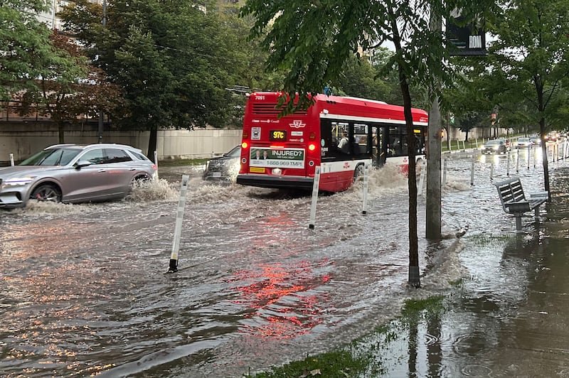
Toronto is continuing to deal with the aftermath of a powerful storm that brought heavy rain, damaging winds, and large hail to the city on Sept. 2, causing widespread flooding, fallen trees, debris, and power outages.
The latest information reviewed by Reportiva indicates that Toronto is now in the cleanup and recovery phase rather than facing a newly confirmed major flooding event on Saturday, Sept. 5. The City of Toronto’s storm-response page, updated Sept. 4, said crews were still removing flood water and debris and responding to hazards reported across the city.
Environment and Climate Change Canada showed no weather alerts in effect for the City of Toronto in its latest city-specific alert update available Friday evening. Its forecast for Saturday called for a mix of sun and cloud, with temperatures around 24–25°C and only a chance of showers in the afternoon, depending on the forecast point.
Flooding followed intense Sept. 2 storm
The flooding was part of a much broader severe-weather event that moved across southern Ontario on Wednesday.
Environment Canada had warned ahead of the storm that thunderstorms could bring damaging wind gusts, large hail and torrential rainfall. The agency’s warning for Toronto cited the possibility of rainfall amounts reaching 50 millimetres in some areas, along with a risk of tornadoes.
The storm subsequently caused flooding and significant disruption across the Greater Toronto Area. Local reporting documented roughly 50 to 60 millimetres of rainfall in Toronto, with winds reaching about 100 km/h in the city and surrounding area. Flooding and debris affected roads and transit routes.
The Don Valley Parkway was among the major transportation routes affected. Its southbound lanes were reopened after flooding forced the expressway to close during the storm, while crews continued work on other affected roadways.
Toronto Fire Services also faced an unusually heavy workload. Toronto Today reported that firefighters received nearly 1,500 calls over 24 hours surrounding the storm, making it the department’s second-busiest day on record.
City crews remain focused on recovery
Toronto’s official storm-response page said the city had received approximately 2,400 service requests by Sept. 4 as crews assessed hazards and prioritized areas requiring attention.
Crews were removing flood water, clearing debris and dealing with storm-related damage. The city warned drivers to use caution and not drive through standing water. Some traffic signals were also affected by power outages, meaning motorists were advised to treat affected intersections as four-way stops.
The city also said some park facilities and washrooms could remain affected by flooding. It advised residents that swimming in Lake Ontario was unsafe for at least 48 hours after heavy rain because of the effects of stormwater runoff.
Power outages largely restored
The storm also caused widespread electrical outages.
Toronto Hydro said the Sept. 2 wind and hailstorm affected thousands of customers. By the morning of Sept. 3, the utility said approximately 90% of affected customers had regained power, reducing the number without electricity from a peak of about 65,000 to roughly 6,000.
Toronto Hydro said restoration crews were continuing to address electrical hazards and repairs, including damage caused by fallen branches and debris. The utility advised residents to stay at least 10 metres away from downed power lines and treat them as live.
TTC service recovered after storm disruptions
Public transit was also disrupted as flooding and blocked roads affected parts of the network.
The TTC said on Sept. 3 that service was operating across the network after employees made rapid adjustments during the storm. The agency said its buses, Wheel-Trans vehicles and much of the streetcar, subway and LRT network continued operating despite flooding, hail, strong winds and debris.
Some routes were temporarily diverted or suspended because of flooding and blocked roads. The latest TTC service information reviewed by Reportiva shows subway and light-rail lines operating, although individual surface routes can still be subject to changing detours or closures.
What Toronto’s weather looks like today
The immediate weather picture is considerably calmer than it was during Wednesday’s storm.
Environment Canada’s latest available Toronto forecast calls for a mix of sun and cloud on Saturday, with a high near 24–25°C. The forecast does not indicate the kind of severe thunderstorm setup that preceded the Sept. 2 flooding, although isolated showers remain possible depending on location and forecast period.
That distinction matters because searches for “Toronto flooding today” may still surface dramatic images and reports from Wednesday’s storm. Those images are genuine, but they document the Sept. 2 event rather than establishing that the same level of flooding is occurring across Toronto on Sept. 5.
The city’s latest official storm-response information available for this report was updated Sept. 4 and continued to describe active cleanup and recovery work. The next significant change would come from new rainfall, additional flooding, or further road and infrastructure assessments.
For now, the verified picture is one of recovery after a damaging storm, not a newly confirmed citywide flood emergency.
This story may be updated as new information becomes available.